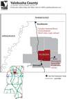
Yalobusha County is located in North Central Mississippi and has ample access to highway, rail, and port facilities to meet the needs of most industries.
Transportation Maps
 |
 |
 |
| Major Highways (PDF) | Airports (PDF) | Railroads (PDF) |
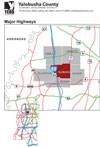
Highways
North/South
- Interstate 55, running from Chicago, Illinois, to just west of New Orleans, Louisiana, passes through western Yalobusha County and parallels historic US 51.
- Highway 7 connects with I-55 to the south and US-278 to the north of the county. Plans are in the works for widening Highway 7 to four lanes, with the first phase beginning in 2010.
- Highway 9W traverses the eastern side of Yalobusha County.
- Highway 315 connects the southeastern corner of the county with US-278 near the US-278/I-55 interchange.
East/West
- Hwy 32 connects northern Yalobusha County with I-55, while Hwy 330 does the same for southern Yalobusha County.
Railroads
- Grenada Railway, formerly the CNIC East line, runs from Memphis, Tennessee, to Jackson, Mississippi, passing through the west side of Yalobusha County and rejoining with the CNIC West line in Jackson.
- Mississippi & Skuna Valley Railroad runs from Coffeeville, in south central Yalobusha County, to Bruce, in Calhoun County.
Ports
Some distances from Yalobusha County cities to river ports:
- 86 miles, Oakland to the Mississippi river port of Rosedale
- 104 miles, Oakland to the Mississippi river port of Greenville
- 109 miles, Coffeeville to the Mississippi river port of Greenville
- 85 miles, Water Valley to Tenn-Tom port of Amory
- 83 miles, Water Valley to Tenn-Tom port of Aberdeen
- 79 miles, Coffeeville to Tenn-Tom port of Aberdeen
- 80 miles, Coffeeville to Tenn-Tom port of Amory
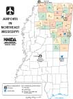
Airports
Average distance to the Memphis International airport from Yalobusha County is about 80 miles.